파일:Vesta-Elevation.jpg
둘러보기로 이동
검색으로 이동
최대 해상도입니다.
Vesta-Elevation.jpg (500 × 500 픽셀, 파일 크기: 43 KB, MIME 종류: image/jpeg)
| 설명 |
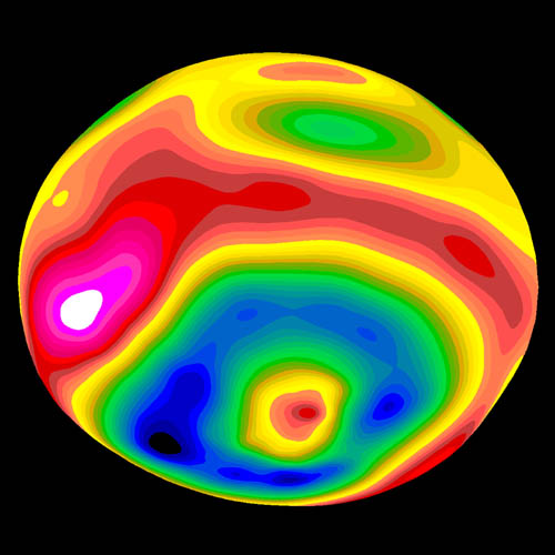
A color-encoded elevation map of Vesta clearly shows the giant 460-kilometer diameter impact basin and "bull's-eye" central peak. The map was constructed from 78 Wide Field Planetary Camera 2 pictures. Surface topography was estimated by noting irregularities along the limb and at the terminator (day/night boundary) where shadows are enhanced by the low Sun angle. Deutsch: Farbkodierte Höhenkarte von Vesta.
Polski: Mapa Westy ukazująca różnice w wysokościach na jej powierzchni |
| 날짜 | Image published 1997 September 4 |
| 출처 | http://hubblesite.org/newscenter/newsdesk/archive/releases/1997/27/image/e |
| 저자 | Ben Zellner (Georgia Southern University) and NASA |
| 저작권 (이 파일을 인용하기) |
Unless otherwise specifically stated, no claim to copyright is being asserted by STScI and it may be freely used as in the public domain in accordance with NASA's contract. [...] [1] |
| 이 파일은 NASA에서 제작하였으므로 퍼블릭 도메인입니다. NASA의 저작권 정책에 따르면 NASA의 자료는 명시하지 않는 이상 저작권의 보호를 받지 않습니다. (Template:PD-USGov, 또는 NASA 저작권 정책 문서, JPL 그림 사용 정책을 참고하세요.) | ||
 |
주의사항:
|
파일 역사
날짜/시간 링크를 클릭하면 해당 시간의 파일을 볼 수 있습니다.
| 날짜/시간 | 섬네일 | 크기 | 사용자 | 설명 | |
|---|---|---|---|---|---|
| 현재 | 2006년 1월 30일 (월) 08:57 | | 500 × 500 (43 KB) | wikimediacommons>Arnomane | higher resolution |
이 파일을 사용하는 문서
다음 문서 1개가 이 파일을 사용하고 있습니다: